


Memory-Map

Beschreibung von Memory-Map
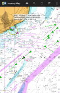
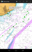
Die Memory-Map-App verwandelt Ihr Telefon oder Tablet in einen voll ausgestatteten Outdoor-GPS- oder Marine-Kartenplotter und ermöglicht Ihnen die Navigation mit USGS-Topokarten, NOAA-Seekarten und anderen Spezialkarten, auch ohne drahtloses Internetsignal.
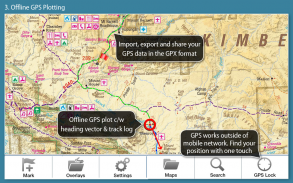
Karten werden im laufenden Betrieb heruntergeladen und können vorab geladen werden, so dass sie offline verwendet werden können. Nachdem die App und die Karten auf das Telefon oder Tablet geladen wurden, ist für die Echtzeit-GPS-Navigation keine Abdeckung des Mobilfunknetzes oder eine Internetverbindung erforderlich.
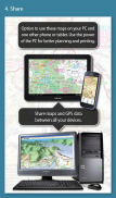
Die Memory-Map-App kann als Standalone-GPS-Navigator verwendet werden. Sie kann jedoch auch in Verbindung mit der Windows-PC- oder Mac-App (kostenloser Download) zum Planen, Drucken und Laden von Karten, Wegpunkten und Routen zum Telefon / Tablet verwendet werden .
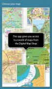
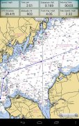
Die Memory-Map bietet kostenlosen Zugriff auf topografische Karten im Maßstab 1: 250.000 und viele andere kostenlose Karten auf der ganzen Welt. Detailliertere Karten können Sie mit einer kostenlosen Demo-Option zum Testen vor dem Kauf herunterladen und erwerben. Zu den verfügbaren Karten gehören Ordnance Survey, Hema, USGS-Quads, NOAA, British Admiralty und DeLorme. Karten können auf Ihrem PC sowie auf Ihrem Telefon und Tablet verwendet werden. Mit der Cloud-Synchronisierungsfunktion können Sie die Overlay-Daten auf allen Ihren Geräten konsistent halten.
Features sind:
Greifen Sie auf eine Vielzahl von weltweiten Karten und Diagrammen zu.
Lädt automatisch eine kostenlose Karte Ihres aktuellen Standorts herunter
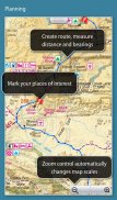
Erstellen und bearbeiten Sie Markierungen und Routen.
Importieren und exportieren Sie Markierungen, Routen und Tracks im offenen GPX-Format
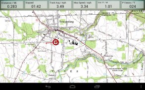
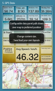
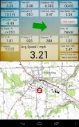
Anzeige; Position, Kurs, Geschwindigkeit, Richtung, Höhe und Durchschnittswerte
Die Positionskoordinaten umfassen Lat / Long, UTM und GB Grid
Einheiten werden in Statut, Nautisch oder Metrisch angezeigt
Unterstützung für GPS- und Compass-Sensoren, sofern verfügbar.
Ortsnamenindex, kann offline verwendet werden.
Karte verschieben, GPS-Position sperren und automatisch scrollen
Zeichnet Breadcrumb-Trail / Tracklogs auf.
Teilen Sie Positionsmarken oder Tracklogs als GPX-Dateien
Annäherungsalarm
Volle Marine-Instrumentierungsfunktionen mit AIS-, DSC- und Ankeralarm
NMEA-Datenschnittstelle über WLAN oder Bluetooth
AIS-Kollisionsalarm mit einstellbaren Grenzwerten für Ziele der Klasse A und Klasse B
Anzeige von Alarmbenachrichtigungen und Nav-Daten auf der Android Wear-Uhr
Barometer & relative Höhe
Memory-Map – Version 2.9.0
(03-02-2021)
Memory-Map – APK Informationen
APK Version: 2.9.0Paket: com.memorymap.mm2Neueste Version von Memory-Map
Weitere Versionen


Apps in derselben Kategorie

Das könnte dir auch gefallen...


